Archaeology
Roque Teneguía
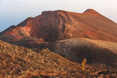
Roque Teneguía is part of the Cumbre Vieja Nature Park, which covers the entire centre-south of the island, spreading across five municipalities (Fuencaliente, Mazo, El Paso, Breña Alta and Breña Baja) with an area of 7,499.7 hectares. The park was created by Law 12/1987, of 19 June, on the Declaration of Natural Spaces of the Canary Islands, as two separate spaces: the Cumbre Vieja and Teneguía nature park and the natural site of national interest of the lava flows of the Martín volcano. Both were joined by Law 12/1994, of 19 December, although the Teneguía Volcanoes became an independent protected space, with the category of Natural Monument and an area of 857.4 hectares.
Roque Teneguía is part of the Cumbre Vieja Nature Park, which covers the entire centre-south of the island, spreading across five municipalities (Fuencaliente, Mazo, El Paso, Breña Alta and Breña Baja) with an area of 7,499.7 hectares. The park was created by Law 12/1987, of 19 June, on the Declaration of Natural Spaces of the Canary Islands, as two separate spaces: the Cumbre Vieja and Teneguía nature park and the natural site of national interest of the lava flows of the Martín volcano. Both were joined by Law 12/1994, of 19 December, although the Teneguía Volcanoes became an independent protected space, with the category of Natural Monument and an area of 857.4 hectares.
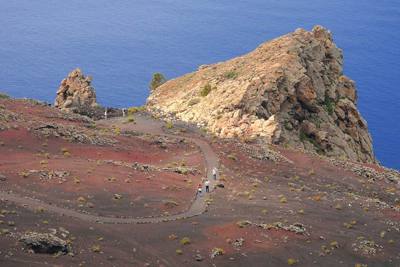
Roque Teneguía, declared an Asset of Cultural Interest in 1985, covers an area of roughly 2,000 m2. It stands on the south-west slope of the San Antonio volcano, at around 418 metres above sea level. It is a very old geological formation, estimated to be about 600,000 years old — specifically a promontory of haüyne phonolite, pale yellowish-pink in colour. Roque Teneguía is 30 to 35 m high from east to west and 80 m from north to south. The site is reached by a track that skirts the slope of the San Antonio volcano and branches off towards the crater of the Teneguía volcano. From Los Canarios to the Roque there is a distance of roughly 5.5 kilometres, although the last 500 metres are covered on foot over a blanket of lapilli. This rocky eminence is visible from the south and west and served as a landmark for fishermen and coastal navigation.
Thirty-eight years ago now, Roque Teneguía came close to disappearing. In March 1970, a group of young people from Fuencaliente — Juan José Santos Cabrera, his brother Octavio (deceased), Rosa Díaz Martín, Toña Carballo Pérez, Juan Luis Curbelo Pérez and Rafael Díaz Pérez — visited the director of the Archaeological Museum of Santa Cruz de Tenerife, Luis Diego Cuscoy, showing him photographs of the place and bringing him the alarming news of its imminent disappearance: the route of the Barlovento–Fuencaliente water channel had been laid out through that spot and was to pass right at the level of the Roque. The works were at a very advanced stage, to the point that they were already approaching the base of the Roque; it had, moreover, been mined, and the blasting was due to take place within days. The news justified the alarm of Luis Diego Cuscoy, who immediately reported the situation to the commissioner general of Archaeological Excavations, Martín Almagro. His swift action brought the immediate intervention of the director general of Fine Arts, Florentino Pérez Embid, who telegraphed the mayor of Fuencaliente, Emilio Quintana Sánchez, to halt the works.
The works were stopped and Roque Teneguía could be saved, preserving its impressive set of engravings, on which Luis Diego Cuscoy then carried out two campaigns, in 1970 and 1971 respectively, obtaining tracings and photographs as well as a study of techniques and patinas, in addition to several excavations.
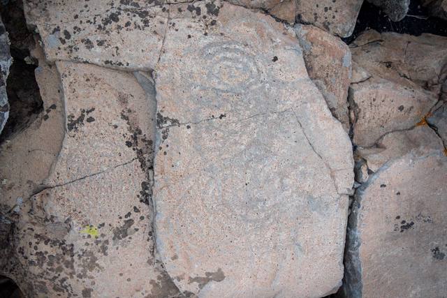
Its botanical or phytogeographical interest is due to the presence of the "cabezuela" (Centaurea Junoniana), of which a few specimens live clinging to the crevices of the Roque — its last refuge on the whole island. But without doubt its greatest attraction is an important set of rock engravings, one of the most outstanding on the island of La Palma. Its eastern face bears an astonishing number of engravings, more than 150 motifs. They appear in isolation or in groups, among which the meanders and spirals stand out. They were made using coarse, medium and fine pecking techniques. The current state of Roque Teneguía is not what one would wish: it shows fractures, caused by the earthquakes that accompany volcanic eruptions; for centuries it was also the quarry from which the nearby residents of Los Quemados and Las Indias extracted stone to build their houses, as it was the only building material available at the time — the rest of the ground was covered in lava, ash and sand. Historically, the Roque has suffered greatly to stay standing. It was also affected by the blasting carried out to run the main water channel just beneath it, cutting through it, and finally by recent human impact, which has left its mark on the stones (scratches, and names that many visitors have carved even over some of the rock-art symbols).
Roque Teneguía holds almost 80 panels of different sizes and more than 150 motifs. Owing to the wear and the patina of the rock motifs, most of them cannot be made out during the day. The best time to see the engravings is at dawn and at dusk, in almost grazing sunlight. These symbols allow us to travel beyond perceived reality, to approach and even cross the borders of the apparent scene and reach a deeper knowledge of things. One of the procedures for discovering sacred sites is the orientatio; it is a very ancient concern, carried out according to solar criteria. From the earliest times, orientation became a whole ritual for experiencing the need to place oneself in a cosmically organised world.
Roque Teneguía was a sacred place for the Awara, a celestial archetype whose transcendence rises from its precise solar positions on the horizon. The Roque is the physical structure that gathers both space and the heavenly bodies into a single will — the fixing of a space that is constantly re-actualised and re-created in sacred times. Symbolic thought projects a sacred geography onto the landscape as a culturally imagined space, heightening the value of reality.