Route · 9 stops
Recreational Areas
Rest areas, parks and spots in the pine forest for a break during your visit.
Route map
Use ⌘/Ctrl + scroll to zoom · two fingers on touch screens
Discover the route
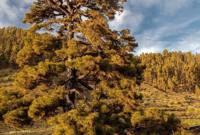
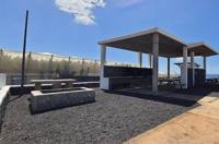
Rest areas, parks and spots in the pine forest for a break during your visit. On the coast, the Puntalarga recreational area, opened in 2014, is the only seaside one on the island, with barbecues, tables for a hundred people and access to the beach. Next to Los Canarios, the rest area with barbecue and toilets on the road to the football ground, the picnic tables of the Los Canarios Viewpoint on the LP-2 and El Pinalejo, with its playground. In the pine forest, the Pino de Santo Domingo, with its recreational area of 2011 at a crossing of paths; the Pino de la Virgen, with a pilgrimage in August; the Fuente de Los Roques, above 1,000 m next to the Ruta de los Volcanes; and Llano del Tanque. In Los Quemados, the Parque de la Fuente. Facilities vary: confirm the services and access conditions, especially in the forest areas.
Sites
- Los Canarios viewpoint and recreational area.
- Fuente de Los Quemados Park.
- Fuente de Los Roques Recreational Area.
- Pino de Santo Domingo.
- Los Canarios Rest Area.
- El Pinalejo.
- Puntalarga Recreational Area.
- Llano del Tanque Recreational Area.
- Pino de la Virgen.
Before you set off
- Check the restrictions in force due to fire risk.
- Do not use barbecues outside the authorised conditions.
- Bring your own water and take all your rubbish with you.
- Check the condition of the forest tracks.
To print (offline) and listen
This page is also available as a printable document and as audio.