Trail · 4 stops
Trail 1: Los Canarios – El Charco
Municipal trail from Los Canarios to the village of El Charco, past the viewpoint of the same name.
Route map
Use ⌘/Ctrl + scroll to zoom · two fingers on touch screens
Discover the route
From Los Canarios to El Charco across the high ground of the municipality: a mid-slope path that climbs between the upper vineyards and the Canary pine forest and descends to the district of El Charco, ending at its viewpoint over the Tamanca Protected Landscape. It is not a waymarked trail in its own right: it uses 1.5 km of the GR 131 and then the GR 130, the trail that circles the island.
Fact sheet
- Start: Plaza Minerva (Tourist Office), Los Canarios, at 715 m.
- End: Casa de Camineros de El Charco and Mirador de El Charco, on the LP-2.
- Distance: 7.52 km.
- Cumulative elevation: 274 m of ascent and 223 m of descent.
- Duration: 2.5 h one way; 5 h there and back.
- Difficulty: moderate.
The route
From Plaza Minerva take the Carretera General to the left and the second street on the right, towards the church of San Antonio Abad, a listed Site of Cultural Interest. There the GR 131 section begins, which is followed for 1.5 km to the junction with the GR 130 in the direction of Los Llanos de Aridane. About 150 m further on is the Pino de Santo Domingo Recreation Area, a meeting point for walkers arriving along other trails.
A 1.5 km climb follows through the upper vineyard area, where mainly Listán Blanco and Negramoll are grown. Depending on the time of year you can see verode, white tajinaste, mountain codeso and corazoncillo, although the Canary pine dominates, which in recent years has suffered two major fires: the bark is left black, but the tree sprouts again easily. Among the pines, clearings open up with views of the south-east coast of the island.
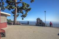
The path then descends to the Casa de Camineros de El Charco. Turning left along the main road, 700 m further on is the Mirador de El Charco, with views of the Tamanca Protected Landscape: from the summit pine forest to the coastal tabaiba scrub and the coastal strip of the Marine Reserve.
How to get back
At the Casa de Camineros the line 210 bus (Los Llanos de Aridane – Fuencaliente) stops, which takes you back to Los Canarios. You can also call a taxi or return on foot along the same path.
Before you start
- Bring water, a cap, sun cream, hiking boots and some food.
- The final section coincides with the GR 130 (stage 6), which the Cabildo keeps only partly open because of works on the LP-2 and the 2021 lavas outside the municipality: check its status on the La Palma Trail Network.
- Check the fire risk in summer and do not light fires outside the authorised areas.
- Emergencies: 112.
To print (offline) and listen
This page is also available as a printable document and as audio.