Trail · 5 stops
GR-131: Volcano Route
Southern section of the GR-131 long-distance trail: from the Martín volcano to the Fuencaliente Lighthouse via Los Canarios, San Antonio and Teneguía.
Route map
Use ⌘/Ctrl + scroll to zoom · two fingers on touch screens
Discover the route
The GR 131 is the long-distance trail that crosses La Palma from north to south along the ridge. Its stage 3, from the El Pilar Refuge to Fuencaliente (23.7 km, high difficulty), is the famous Volcano Route, which crosses the youngest land in Spain. The section described here is the last one: from Los Canarios to the Fuencaliente lighthouse, between the San Antonio volcano and Teneguía, down to the salt pans and the two lighthouses at the southern tip of the island.
Fact sheet
- Start: Plaza Minerva (Tourist Office), Los Canarios, at 715 m.
- End: Fuencaliente lighthouse.
- Distance: 7.4 km one way; 14 km there and back.
- Cumulative descent: 706 m.
- Duration: 3 h one way; 5 h there and back.
- Full Cabildo stage (El Pilar Refuge – Fuencaliente): 23.7 km, high difficulty, open.
The route
From Plaza Minerva take the Carretera General to the left and the second street on the left, towards the San Antonio Volcano Visitor Centre, a must-see for its panels on the volcanic history of the island. This volcano erupted in 1677 and buried the Fuente Santa, the hot-water spring that gives Fuencaliente its name. You can walk around the crater rim to a viewpoint with views of the south, south-west and west coast.
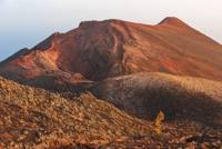
Back on the GR 131, the path continues towards Teneguía. On 21 October 1971 the tremors began; on the 26th the ground cracked open and two rivers of lava flowed out towards the sea; on the 27th the lava reached the coast, surrounding the lighthouse; a crater opened with several side vents that hurled rocks more than 300 m into the air, and a 200 m cone was formed. The eruption continued with new vents until it calmed down around 21 November.
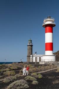
The final stretch leaves the pine forest behind, with tizón lizards and the odd raven, and the vineyards of the Fuencaliente wines appear. Lower down the vegetation is reduced to creeping plants on the lapilli and lichens on the volcanic bombs: a lunar landscape in which life slowly gains ground. The trail descends to the coast to the two lighthouses: the old stone one, which was spared by the lavas that surrounded it, and the modern white and red one. On the left, in terraces stepping down to the sea, the salt pans, a Site of Scientific Interest for the wading birds that live there.
How to get back
The line 23 bus (Fuencaliente – Hotel – Faro) leaves from the lighthouse; you can also book a taxi.
Before you start
- For the full stage the Cabildo warns of heat, lack of water and wind, and of cold in winter: set out before 9:00 and carry plenty of water.
- There is no drinking water on the section; the only spring on the stage is the Fuente de Los Roques, 14 km from the refuge.
- Keep to the waymarked trail: climbing Teneguía is prohibited and the volcanic terrain is fragile.
- Up-to-date status on the La Palma Trail Network (senderosdelapalma.es). Emergencies: 112.
To print (offline) and listen
This page is also available as a printable document and as audio.